Legend
KEY TO THE DAILY REPORTS
As described by Jane in her book Through a Window, we alternated four-day blocks following Figan and his pals. We each used a cassette tape recorder to describe Figan’s social interactions and behavior. When one of us was following Figan on a four-day block, the other would be transcribing tape recordings from his previous four-day block, writing up summaries and reports from the four-day block, and occasionally following other chimps.
We still have many of the original cassette tapes, which we converted to digital. These recordings reveal our own excitement while observing and describing Figan’s exploits, especially when the chimps were hunting and competing for meat.
SUMMARIES AND REPORTS
We wrote our summaries and reports on a manual typewriter in quadruplicate using carbon paper (so, seven layers). Typically the original and top copy stayed at Gombe, and we kept the lower two for our records. Often these lower copies were barely legible. Below is an example of a typical carbon copy.
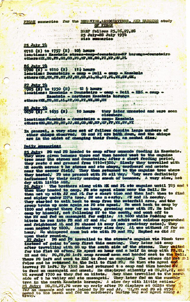
For this book, we converted these hand-typed copies into digital text by scanning them into images and running the images through an optical character reader. So the reports that follow, although now translated and legible, were written almost 50 years ago.
In the original reports the chimpanzee names had two letter codes. Figan, for example, was FG, and his brother Faben was FB. These codes and some of the abbreviations used to describe the chimps’ behaviors have been expanded for improved readability.
TRAVEL AND GROUP CHARTS (T&G)
Each day, whoever was out with Figan was accompanied by one of the Tanzanian staff, who were highly trained at observing and identifying the chimps, in recognizing the foods being eaten, and in mapping Figan’s travel patterns.
While David or Curt was focused on dictating the details of Figan’s behavior and social interactions into their tape recorders, the field assistant maintained written charts and a map of the essential information on Figan’s associations, feeding, and ranging.
Over the course of the day, the field assistant would fill out two T&G charts on paper, one for the morning (asubuhi) and one for the afternoon (jioni), and would also draw a map detailing Figan’s travel patterns. Ideally, the daily observations would begin as soon as Figan left his nest in the morning and would end after he finished building his nest in
the evening.
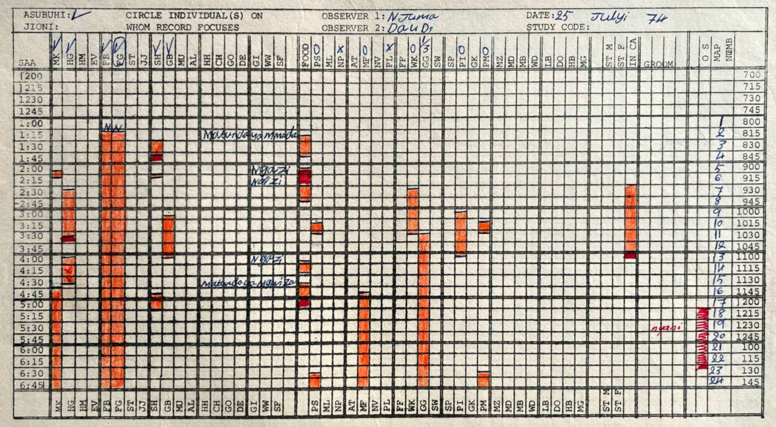
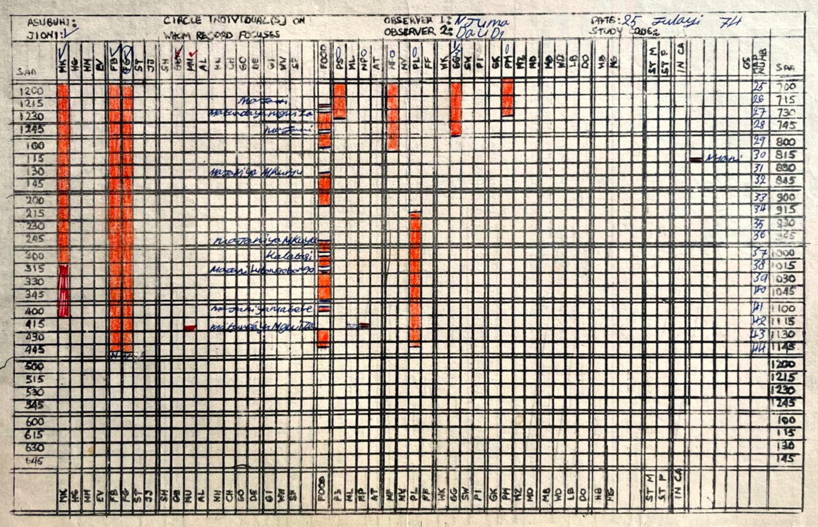
The above charts are from DAY 26 (July 25, 1974) as completed by Njuma Rukamata, who was with David (Daudi) for the entire day. The horizontal lines indicate successive 15 minute intervals. The hours are all in Swahili time (6 hours offset from standard time).
For the top, morning graph (asubuhi), the Swahili hours are shown in the far left column. So, for example, “1:45” is 7:45 am standard time. For the bottom, afternoon graph (jioni), the Swahili hours are shown in the far right column. For example, “11:15” is 17:15 (5:15 pm) standard time. Got it?
Across the top of the chart are the two letter codes for all of the adult and adolescent chimps in Jane’s two communities, first the males, then the females. The colored bars indicate when a chimp was in association with Figan (FG) – that is, within approximately 100 m. In this example, Mike (MK) was with Figan from 08:10 until 08:20, and then again from 10:45 until 17:15.
The circle around FG indicates that he was the focus of observations (“focal animal”). The “N” above his orange column indicates that observations started when he left his nest. The previous night Figan had nested in proximity to Faben (FB).
The zero above the females’ initials indicates that these females did not have swollen bottoms (were not sexually receptive), except for Gigi, whose bottom was partially swollen (B = 1/3).
On the far right of the charts is the column “MAP NUMB,” which indicates Figan’s location at 15 minute intervals on the accompanying map (see below). So at 08:15 am he was at location “6,” near the path
below Peak Ridge.
In the middle of the charts is a column for “FOOD,” indicating the time intervals that Figan was feeding. The Swahili names for the foods are written to the left. For example, from 14:40 until 15:15 he was eating leaves (Majani ya mkuyu) in location 32 to 34 (Lower Kakombe Valley – see the accompanying map below).
Toward the right side of the chart is a column to indicate whenever Figan was in Chimp Camp (“IN CA”). On this day Figan visited Camp from 08:30 until 10:08.
Farther to the right is a column for other species (“OS”), in this case baboons (nyani), which were present from 11:15 to 12:35 and again briefly in the afternoon.
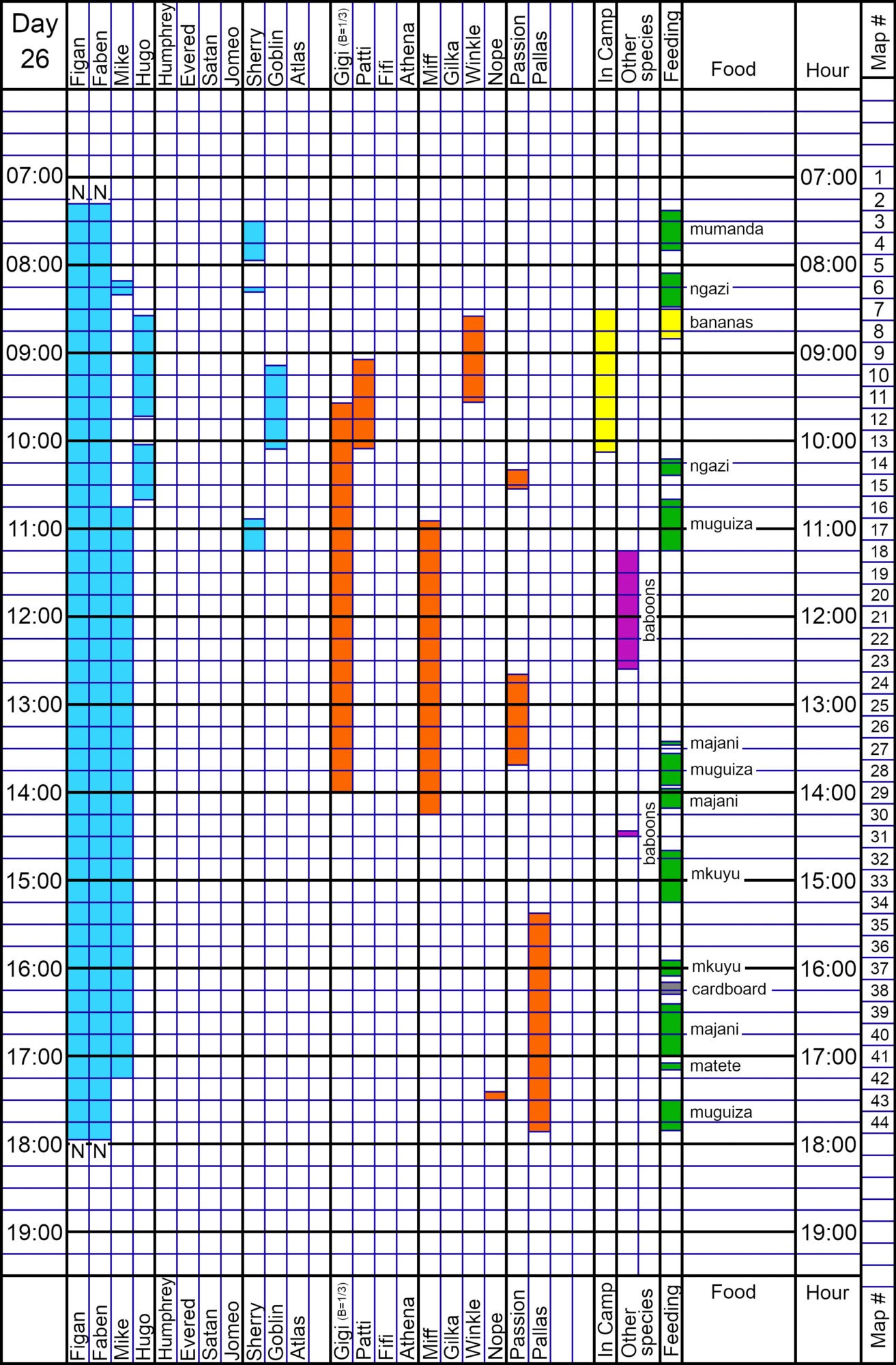
For this web site, we have transcribed the two original charts into a single chart (for example, above) for each of the fifty days. These new charts contain the exact same information as the originals, but in a more readable format.
MAPS
On Day 26, Njuma also completed a map showing Figan’s location throughout the day (below). The map for this day included the main two valleys of Figan’s home range, Kasakela and Kakombe, which extend from the top of the map (the Rift mountain, to the east) to the bottom of the map (Lake Tanganyika, to the west).
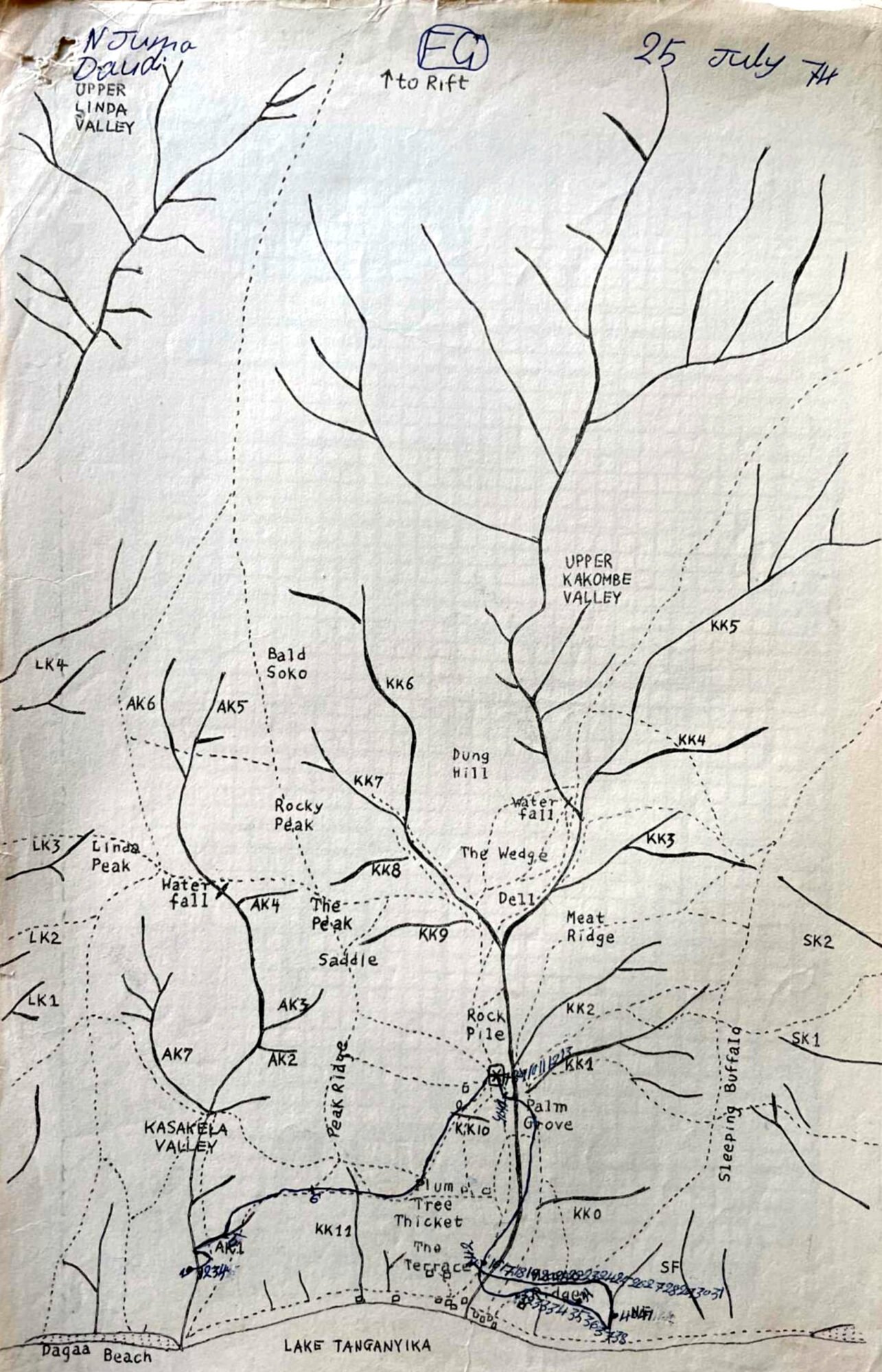
Most of the main valleys have a running stream, typically 5 to 10 feet wide, as well as several numbered tributaries (korongo, in Swahili). For example, Kasakela Valley has tributaries from AK1 through AK7; Kakombe Valley has tributaries from KK0 through KK11. We make extensive reference to these korongos in our summaries.
Most of the major valleys have a waterfall, which is usually a reference point to divide the lower part of the valley from the upper part. We would often write, for example, that Figan was in “Lower Kasakela,” meaning that he was in Kasakela Valley between the waterfall and the lake. The dashed lines on the map are human-made trails, many of which converge on Chimp Camp, the small square box just above KK10.
Between Kasakela and Kakombe Valleys is Peak Ridge, which Jane climbed every morning after arriving at Gombe in 1960 on her quest to find chimps. Also marked on the map is The Peak, where Jane spent long hours watching and listening for chimps, and where she made some of her first important discoveries.
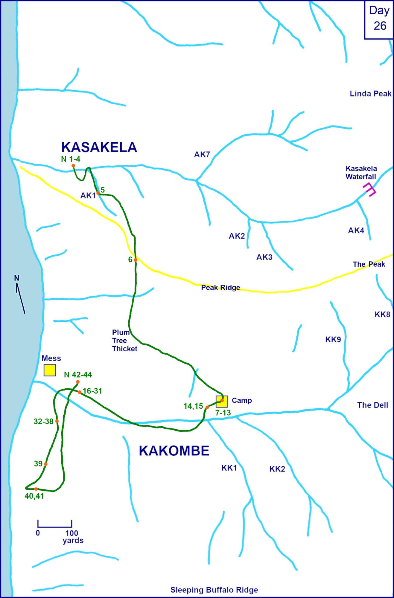
For this web site, we have transcribed the original maps into a vertical (North-South) format (above). Figan’s travel route is depicted in green; the small orange circles indicate his location at 15-minute intervals. The yellow line is the path from the lake up along Peak Ridge to The Peak and beyond.